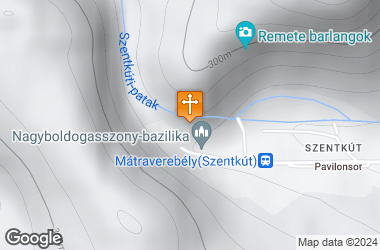
The National Shrine, Mátraverebély-Szentkút is located 20 km south of Salgótarján. Take the main road No. 21 until the village of Mátraverebély, from where you take a 5 km access road to the Szentkút valley.
History
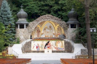
According to folk tradition, in 1091 or 1092, the source of today's Holy Well came from the foot of King Ladislaus's horse hoof. The first bodily healing took place between 1095 and 1195, when the Virgin appeared to a silent shepherd with a little Jesus in her arm and healed with the spring water of today's Holy Well. In 1714 Márton Lukovics, priest of Kisterenye, wrote the centuries-old oral tradition down. In 1210, due to the large number of pilgrims from Szentkút, the Vereb family built the first pilgrimage church in the village of Verebély. By 1258 this temple already had a pilgrimage privilege.
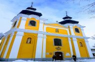
On the 9th of nov. 1400, Pope Boniface IX. allowed the sanctuary a celebration that was only available at the Porciunkula Church in Assisi and at the Church of the Holy Virgin in Aachen on the Feast of Saint Margaret. He granted confession permission to 12 priests for the Assumption of the Holy Virgin and the three days immediately preceding it. (Monumenta Vaticana Volume IV, Diploma 312). In 1700 Pope Clement XI. investigated some of the miraculous healings at Holy Well and accepted their veracity. The first stone chapel was built in 1705 in Szentkút. In 1710 Pope Clement XI. had already fully linked this chapel to pilgrimage. János Almásy, thanks to the extraordinary healing of the Jasians and Cumans in Szentkút, with the help of Antal Bellágh and Ádám Bellágh, a hermit priest from Szentkút, built the present church and a monastery from 1758 to 1763. Mihály Szentmihályi parish priest, canon of Eger, vice dean In 1767, on the day of the Assumption of the Holy Virgin, after a single bath in the water of Szentkút, he got rid of a painful backache. He wrote the first book on the Holy Well in gratitude in 1794.
On the 17th of July 1782. Pope Pius VI. for all feasts of the Blessed Virgin and for the feasts of St. Anthony of Padua and St. Anne, n the 18th of July 1858. Pope Pius IX. already has the first day of a crusade week, and Pope Pius XI., with his documen 1613/1926, gave the Holy Well a full pilgrimage every day of the year. In 1970, Pope Paul VI. awarded the pilgrimage church with the title "basilica minor" (= small basilica).
Hermits lived in the caves of Szentkút, on the hillside above the present-day church, since the 13th century. The last hermit of Szentkút, Dobát Jozafát died in 1767. His tomb is in the Basilica.
In 1765, János Almásy, owner of the shrine, writes to Prince Ferenc Barkóczy:"... in the time of the Turkish yoke, Franciscan patrons led the faithful on a vow pilgrimage to Holy Well ... Pater Franciscans of Gyöngyös served there and no one could subsist permanently there ...In 1705 the Franciscans led the pilgrimages. " The Franciscans were probably already pastored at the Holy Well during the farewell seasons since the 13th century. From 1710 they stayed with the priests in the area or with one of the faithful. From 1772 they were the inhabitants of the Szentkút monastery.
The state expelled the Franciscans from their nearly two centuries-old home in 1950. Until 1989 the Esztergom Diocese provided the place of worship and since then Franciscans have been serving again at Szentkút.
In 2006, on the occasion of the Assumption of the Holy Virgin, Cardinal Péter Erdő, the primate, solemnly proclaimed the Holy Well to be a National Worship. |