The first Geopark both of Hungary and Slovakia, which is the first transnational geopark, reunites people and landscape, it is an ancient world without borders.
he idea of a common geopark which is able to introduce and manage geological exhibition places, other natural and built heritages those lay near to the boundry, first popped up in the professionals of the Bükk National Park and the Slovakian Cerova Vrchovina in the late ‘90s. In 2001, experts of both countries compiled a thematic geological path with help of the resources of the European Union, then in 2005 the Hungarian preparations for planning the Geopark of Nógrád started. As a continuation of this, in the beginnig of 2008 the Hungarian Geological Society checking up with Slovakian partner organizations completed the detailed inventory of values of the future geopark.
Due to several years’ organized and co-ordinated professional work, the Novohrad- Nógrád Geopark -with one of its central scenes in Ipolytarnóc- became a member of the European Geopark Network on 27. March 2010. Then during the 4th Global Geopark Conference on 14. April 2010 in Malaysia, Hungarian and Slovakian experts received a document stating the membership of the Global Geopark Network as a sign of international acknowledgement.
The first Geopark of Hungary and Slovakia -which is the first geopark that spread over borders- means a major international success for the region, while this title is very difficult to get. It is connected to fulfilling of requirements in the fields of value-protection, preservation of traditions and regional development and almost one hundred candidates are still waiting for admission into the world-wide network of geoparks.
The frontier regional co-operation affects 5 microregions and 65 settlements on the Hungarian side, moreover 3 micro- regions and 30 settlements on the Slovakian side of the border. In the logo of the Novohrad- Nógrád Geopark you can see the castle of Somoskô. The country border of Trianon runs at the foot of the castle, which sometimes divides these two nations even today. In the picture it is symbolized by the brake of the semicircular labelling at the tip of the castle-tower. But the castle is a common strength being feed on the past, standing on a basalt cliff. Under it the stylized picture of the bent basalt columns can be seen, which are internationally famous and can be found at more sites in the neigbourhood.
Values of the Geopark
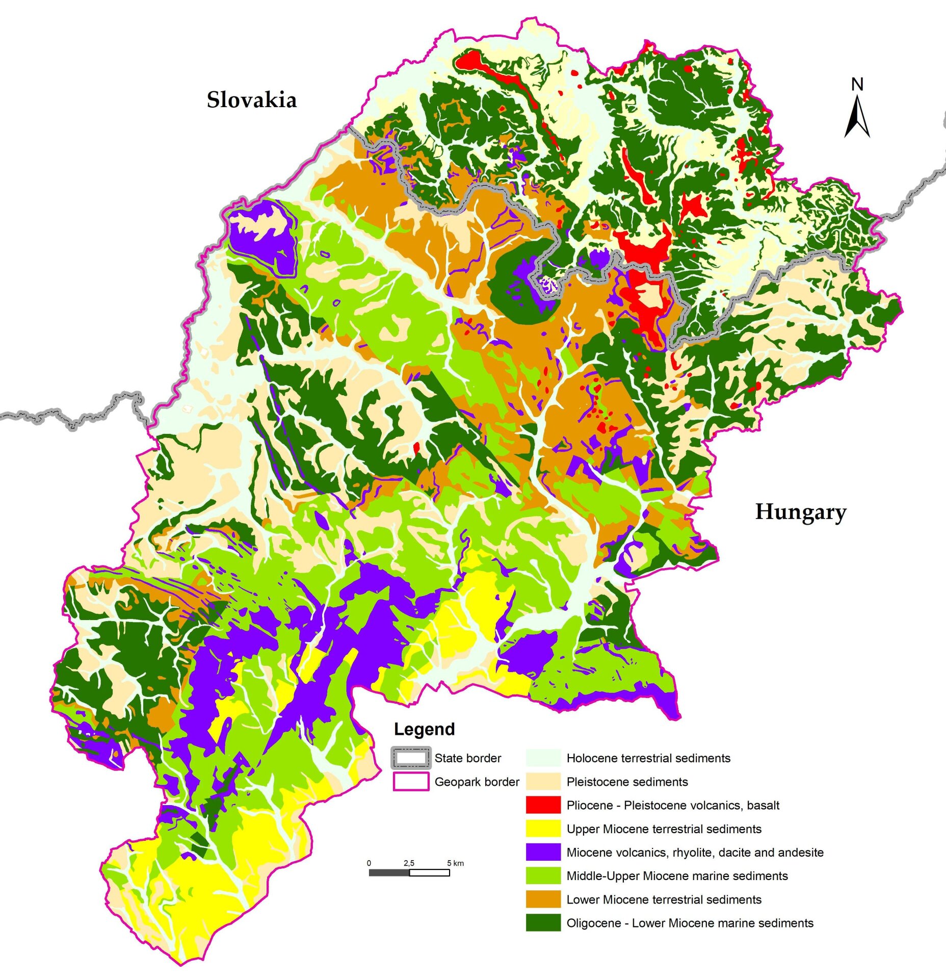
Novohrad-Nograd is in Central Europe with a peaceful cross border landscape surrounding us. But do not be mistaken, its geological past was harsh. Collision of microtectonic plates pushed up the Carpathian Mountains and created a mosaic-like structure of accreted terrains, giving birth to the Pannonian Basin. Diverse volcanism shows that elemental forces were involved in the process, spanning the last 20 million years and ending just before our current Era. The volcanoes created during this process have created a laboratory of treasures forthe Slovak-Hungarian Novohrad-Nograd Geopark.
Luckily, the remnants of the rich volcanic heritage of the transboundary geopark are accessible, not only for the professionals but also for the public and visitors. There is easily read interpretation at the geosites to inform experts, local people and visitors of the importance of the volcanism to the local people and to enhance the economic value of this area by geotourism.
The fiery volcanic eruptions produced rhyolitic ig nimbrites, devastating ash flows that covered tropical habitats in Kazar, preserving them, for example the world-famous fossils of Ipolytarnoc, a Prehistoric Pompeii. Later submarine and subaerial lava flows, fed by magma chambers, created andesitic composite volcanoes that formed isolated islands in the subtropical sea. Due to erosion, the inner structure of the andesitic volcanoes has exposed feeder dykes in several places. The alternation of lava flows and colourful tuffs with calcareous marine sediments appear like huge layered birthday cakes, as seen in the quarry of Samsonhaza. In higher areas there are uplifted and eroded blocks. There are also km-long volcanic vents and large dyke networks which expose veins of former extinct volcanoes; the roots of a hazardous past.At Ber an exceptional outcrop exposes the curved columns of an andesite body, the so-called “andesite-slide”. The columns were formed when hot andesite lava flowed into a large depression and slowly cooled. As the lava cooled, it shrunk and joints and fractures formed perpendicular to its margins thus creating the columns.
The youngest volcanoes of the geopark created the Novohrad-Nograd basalt volcanic field. They comprise almost 100 individual volcanic centres, formed periodically, in six active volcanic phases. The basalt volcanism started some 6 million years ago, with interruptions lasting several hundred thousand years and ending only 100 thousand years ago. During its dormant phases, further volcanism may have occurred. Additional volcanic basaltic features are to be seen in the areas nearby and these include “petrified” gas bubbles, lava spatters, maar volcanoes, scoria and cinder cones, lava flows and lava plateaus.
Today land and man work together, as in the volcanic peaks that are topped by medieval castles - thus linking human history with its geological past. The emblem of the Geopark depicts the Somoska Fortress, standing on basalt. At its foot runs the state border, which has divided the land and its communities since the First World War. Yet with its curved columnar basalt, its volcanic rocks, the shared castle hill could reunite the present with the past in this transnational geopark.
Since the appearance of the human species geological shapes powerfully influenced the civilization that was being born in their surroundings. These got more and more entwined with each other in the course of time, since men more and more used and shaped their environment. The various geological construction resulted in an accentuated surface. Due to this inhabitants of small villages, nestling in hidden valleys, isolatedly created their unique, highwrought wear and they have been respectful for traditions for centuries. So it is not surprising that Hollókô which lays within the borders of Nógrád –Novoghrad Geopark was the first place in Hungary which was recognized as a part of the World Heritage in 1987. The border fortress system which was built onto the volcanic conduits in the middle-age is the main characteristic of the landscape, but cave-dwellings and churches hollowed out in the sedimental rock or the memories of mining are interesting examples of the coexistence of humans with environment.
Thus, beside Ipolytarnóc several significant geological objects, nature conservation areas and built heritages can be found within the geopark on both sides of the country borders. The area can be proud of its rich and valuable livingworld, which is proved by the fact that a part of river Ipoly, which is the borderline between the two country, is a NATURA 2000 area which means a European protection.