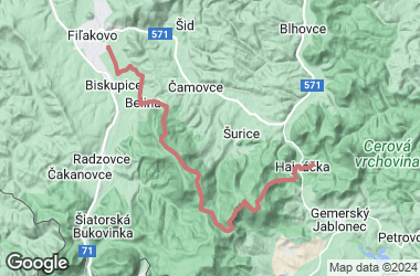
Length: 21,5 km / elevation: 125m / time: 0:40 min. / difficulty: hard / yellow, red and green marked paths
Most important sights during the path:
The Rocks of Belina – outlook N48°13.594' E19°51.913'
The Rocks of Belina (Belinské skaly) formed on rocky border of the basalt ridge of the Belina peak are presenting the lava flow structure streamed from the Monosa volcano (584 m). To its most characteristic formations belong the Dragon´s teeth, the Mathyas Tower and the Bastion. The cliff ends at the Čamovce mine, the geological excavation of which extends up to the bottom of marine sediment.
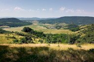
The outlook offers panoramic views of the Karanč hill and villages Čakanovce and Radzovce. On the Rocks of Belina there is an impressive weathering of basalt with pillar and plate separability and with sloping movements.
Hajnáčka Castle hill N48°13.081' E19°57.304'
The cliff of the Hajnáčka Castle hill is the result of a strongly eroded volcanic diatreme, on which a castle was built in the Middle Ages. The cliff made up the castle walls as well, into which people built and carved the building and stairs.The remains of the palace and tower walls can be found on the hard to reach upper part of the castle with a gunpowder cellar.
Pagan Castle N48°11.907' E19°55.333'
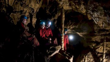
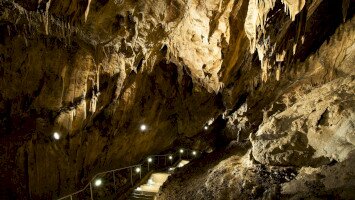
On the southwest from Hajnáčka we can find the most intact lava cover of the Cerová vrchovina Mountain, the Pagan Castle (Pohanský hrad). It lays between Stará Bašta, Hajnáčka and Šurice villages. The most valuable points of ineterest are the remains of Celtic fringe masonry, the “rock street” under the souther edge, sloped rocks (Dvojitá skala, Čertova skala), pseudokarstic caves, the Pillared cave (182 m) and the Labyrinth-cave (151 m) which are the biggest.